Melbourne Train Map 2026
Officially the "Victorian Train Network Map 2026", if you want to be precise about it.
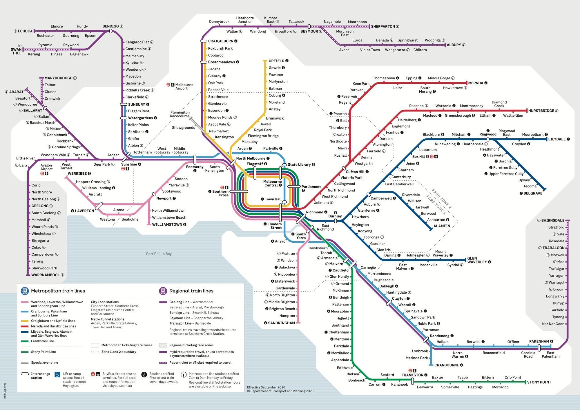
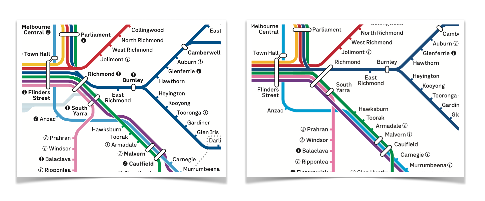
Here is Melbourne's new train map for 2026, showing the Melbourne Metro tunnel's route between Cranbourne/Pakenham and Sunbury, the new pink colour for the Werribee/Williamstown lines, as well as multiple small changes throughout.
There's some good bits, and definitely a few ugly bits. Let's dive in.
The good and expected:
- Metro tunnel gets its full standing on the line, compared to the "Summer Start" map of late 2025 where it's shown as a separate shuttle alongside existing services.
- Linking Pakenham and Cranbourne in the east with Sunbury in the west, the blue line going via new Metro Tunnel stations Anzac, Town Hall, State Library, Parkville and Arden as shown under contruction for many years.
- Reasonable representation of long-planned service changes, including:
- Frankston Line (green) is back in the City Loop
- Sandringham line in the east (pink) joining the Werribee/Laverton/Williamstown lines in the west (previously green, to be pink in 2026)
The okay:
- Fare Zone 1/2 border may be appreciated for some in Melbourne wanting to take advantage of the rare-publicised cheaper fares for 'zone 2 only travel'.
- However there are still zones up to at least 12 in regional areas of Victoria with barely-yet-slightly different fares.
- Showing Zone 1 and Zone 2 so prominently, while ignoring zones 3-12 feels counter productive. My vote: ditch the the zone indicator on the maps. It will get in the way of SRL when that arrives, and it's not helpful to enough people to be so visible.
- The presence of the fare zone border implies it has more importance than it does in Melbourne's mostly-flat-fare cap that gets you anywhere in the state for no more than $11 a day.
The ugly:
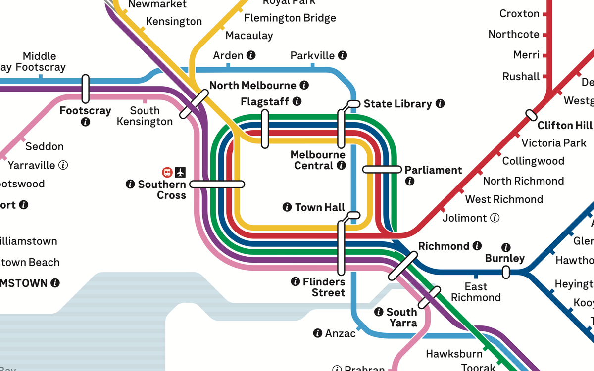
- The kink in the Metro Tunnel line between Footscray and Arden. All have compromises, but having a kink here just isn't necessary.
- The double-crossover of the Gippsland V/Line between Carnegie and South Yarra feels unnecessarily complex.
- The way Sunshine, North Melbourne and South Yarra get a purple V/Line blasting over the top of the station marker to show that they don't stop there looks almost like an error, even though it's shown as intended.
I've shown some examples of how to resolve a few of these issues below.
The missing:
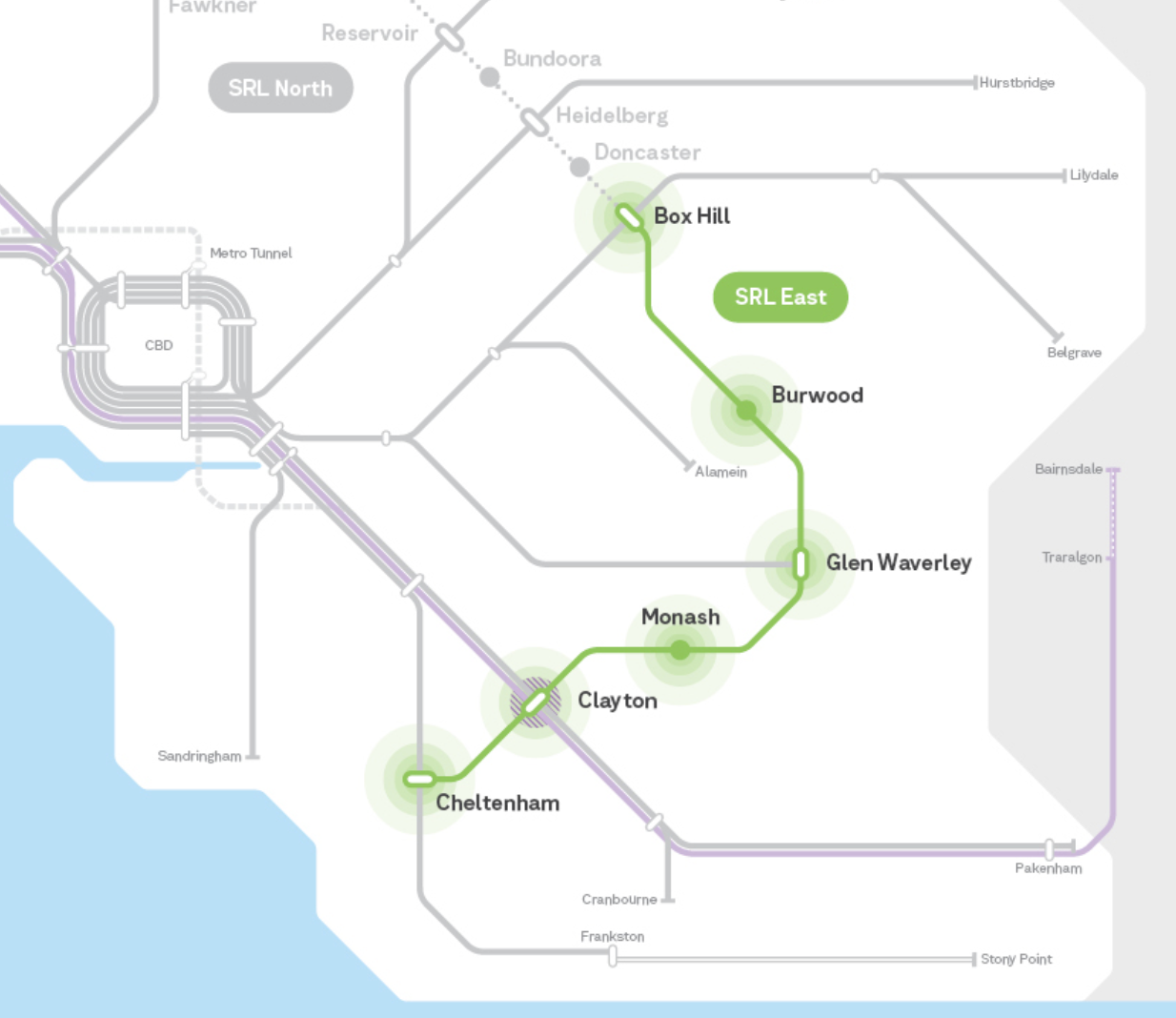
- No SRL East under construction dotted line. Due to open 2035, this feels reasonable to leave off for another year or two. But don't leave it too long.
- The average person in Victoria doesn't closely follow where new lines go, but they can make a huge impact to choices around where to live and work.
- Seeing all the new connections SRL East will offer on a map for years will help many visualise what's to be rolling out in the medium term.
- Likely: new station names will need confirming before showing on a map.
- No Airport Line under construction path, as above, not likely to be delivered until the mid 2030s, so could also appear at a later date.
- Still no indication of which direction City Loop services run:
- Mernda/Hurstbridge lines run clockwise all day, while the Frankston Line runs anti-clockwise all day. These could do with a subtle arrow indicator to show this.
- Without it, users looking at the map still cannot see which way their line goes without checking a timetable, PID, or secondary source of information.
The "it's a service issue not a map issue":
- Lines which change direction in the middle of the day (Belgrave/Lilydale, and Craigieburn/Upfield) are complicated in a way that a map couldn't easily convey.
- Zones and ticketing remains a work in progress – contactless is coming in 2026 and hopefully Express Transit Mode too – and once paper tickets are removed, the paper-ticket-zone will be one less item needed on the map.
Visual Design Fixes to make it Less Ugly
I'm not usually one to criticise without being aware of the challenges, or being able to at least suggest a solution. So here's two.
Footscray-Arden Kink
As an armchair cartographer, here's how I'd approach the "Footscray Arden Kink":
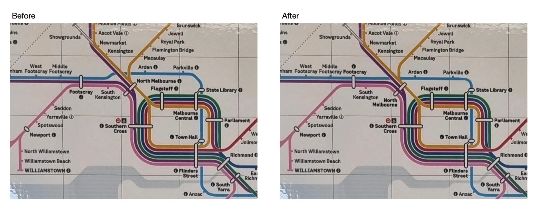
This keeps the rest of the map intact within current dimensions, and also gives North Melbourne a clearer label location.
To be clear, this was a quick mockup as an example of a fix. There's plenty of other improvements that could be made around North Melbourne station on this map.
Gippsland Double Crossover
The way the purple Gippsland V/Line service visually crosses the Cranbourne-Pakenham line, and then also crosses the Frankston line is confusing to follow, and is unnecessarily complex.
A better alternative would prioritise keeping the V/Line straight, and using the space freed up by the Cranbourne/Pakenham line turning before South Yarra, to display the Sandringham line joining at South Yarra.
This also gives the Gippsland V/Line service a cleaner visual bypass of South Yarra (where this line doesn't stop - though maybe it should once the Metro Tunnel timetable arrives in February 2026, freeing up two whole platforms at South Yarra station).
Overall
Overall: I give this map a 7/10. Could do with some more time to iron out the kinks (literally) and hopefully a little more time can be given to getting it polished by the time SRL East and Airport Rail show as under construction on a future version.
Image sources
Now rolling out widely to many trains and train stations, the first photo I had seen of the map in the wild was from Che0063 on Reddit in early December 2025.
As of late December 2025, a higher resolution version is available from the Victorian Government Gazette.
In 2018, a draft version of this map was published, with this useful summary from Daniel Bowen.
This will likely replace the published version of the train map on Transport Victoria's website on or around February 2026.
As of 31 December 2025, this still links to a "Summer Start" version with services on the Cranbourne/Pakenham line in the City Loop as well as running through the Metro Tunnel.